I have this book, Brooke’s Gazeteer. The longer title is The General Gazetteer, or Compendious Geographical Dictionary containing [blah blah blah] the Known World with the [blah de blah de blah] Illustrated by 8 maps. Originally written by R. Brookes, M.D. 13th edition. 1807.
The great thing is that all 8 maps are intact.
Here is the very first entry:
Aa: a river of Dutch Brabant, which waters Helmont, and joins the Dommell, near Bois le Duc
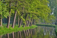
Interestingly enough, there are five more entries for Aa. All of them rivers in, respectively, the United Provinces, Wesphalia, France, Courland, and Switzerland. But here’s a picture of the one I think they mean:
You can see this picture plus read the Wikepedia entry about it. It’s a short entry. Bois le Duc is also in the Netherlands. There is a cathedral there. (St. John’s in case you were wondering). Google is unable to provide directions from Petaluma CA to St. John’s Cathedral in the Netherlands, but here’s a map to give you an idea (you have to click through or scroll a LOT to either side to get the full distance effect):
It would be a long trip for us Left Coasters.
The VERY LAST entry is:
Zytomierz: a town and fortress of Poland, in Volhinia, seated on the Circireif, 120 miles E of Lucko. Lon. 29 22 E, Lat 50 35 N.
There is a You Tube Feed for Zytomierz, which is . . . odd.
It appears that in the Regency, Zytomierz was, in fact, in Poland. Today, however, it appears to belong to the Ukraine. See this set of coordinates which is actually kind of handy and slightly amusing if you read the very very small print at the bottom. Just who are you, Pierre Gorrison?
Well guess what? We go from the River Aa in the Nederlands to Zytomierz, the Ukraine (formerly Poland) and right back to the Nederlands.
Why, you ask? Because Mr. Gorrison is Dutch. He is also on Twitter. @PeterMcAllister AND he lists eBooks in his twitter profile bio. (We are writers and readers here at the Riskies, @PeterMcAllister. We DO eBooks in a big way.)
The only thing more 6-Degrees of Separation would be to find out that Gorrison is related to Dr. R. Brooks, 18th/19th Century Geography geek. OK, maybe it would be even weirder if he was related to the John Deane who neatly wrote his name and the year 1807 in the back of my Brooks’s Gazeteer. Or if one of you knows him. THAT would be weird.
I suspect this blog post will blow his mind (assuming he has Google Alerts). The things people Google and blog about.
I was going to blog about Regency geography, but I got distracted. Sorry. How about that Napoleon?


One thing I love about Risky Regencies is that you can always tell which one of us writes a blog.
This blog could only have been written by Carolyn!!!
(fascinating “travel” and I’m coveting your Gazeteer)
Thanks for an interesting post. Funny how you can start out in one direction and get lost on a detour. It is not always a bad thing. You can come across some interesting stuff. Thanks for the little Bonus Trip.
I do in fact use Google Alerts for my name (although my last name is Gorissen with an ‘e’) and WordPress also has a trackback option alerting me in this case that you linked to my blog.
I have to admit, this must be the funniest blog post I have ever been mentioned in. 🙂
BTW. I am not sure whether I am in any way related to Dr. R. Brooks, but I do in fact live very close (about 10 miles) to Helmond (one of the cities the Aa passes through). And I work in Eindhoven, a place where the other river, the Dommel, mentioned in the entry in Brooke’s Gazeteer passes through.
Pierre: Thank you for your comment! I’m so glad you dropped by. Sorry about misspelling your name.
If you’re ever in Northern California, let me know!